ENESGY FOR PORTS COMPONENTS

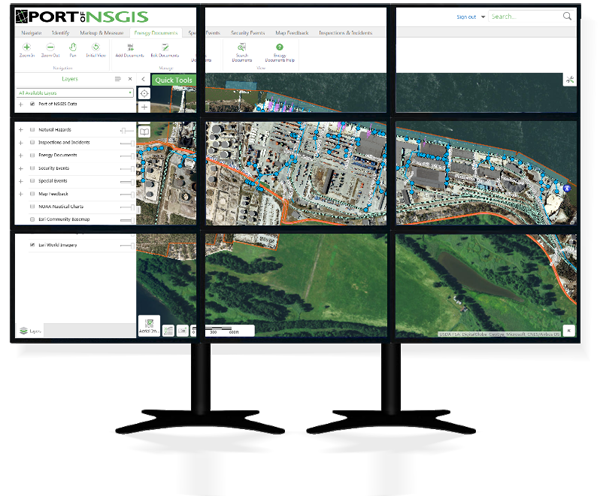
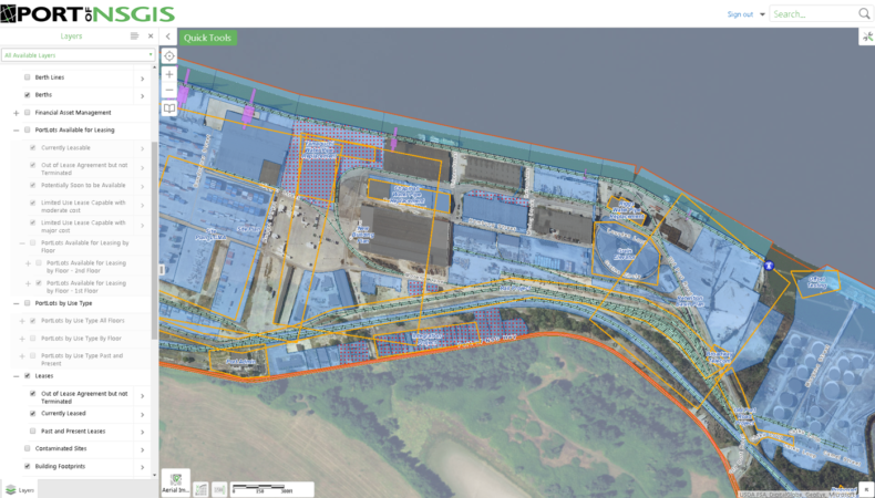
Our solution leverages the benefits of several layered products from world technology leaders Microsoft, Esri, and VertiGIS, and provides specialized ports-specific tools and extensions.

Because NSGIS manages the entire solution, we keep the various components synchronized, deliver maximum functionality with as little reliance on custom software and as much reuse of COTS (Commercial off the Shelf) tools as is possible. The result is a highly focused, yet extraordinarily scalable solution to meet ports’ fundamental needs and provide the basis for future integration and growth.

Deployment Options

Desktop Map Viewer

A powerful viewer, ideal for office use, does not need to be downloaded onto individual desktops, but can be accessed from most current web browsers.

Mobile Map Viewer

A simple viewer for field work and focused tasks that runs on all platforms and web browsers that support HTML5.

Measurement and Sketching Tools

Measure areas and lengths, sketch graphics for on-the-fly map output.

Data Linking Tools

Powerful configuration tools for linking to external databases. GIS can be used as an information integration platform, powering such programs as a Strategic Asset Management Program. It does so by linking dissimilar data from ERP, CRM, or financial systems, using the common element of location. Enesgy for Ports can be configured to connect such systems to maps and empower the display, query and analysis of data, far more effectively than with just database tools.

Search and Query Tools

Tools for locating port assets by current and historic names, addresses, and other identifiers. Search for assets by keyword or filter assets on the map to visualize subsets of data. You can identify all abandoned conduits, search for a specific storm drain from the field, or even isolate all roads within a certain distance of a major hazmat spill.

Data Drill-down Tools

Discover detailed information about mapped assets directly from the GIS database and, optionally, other corporate databases

Standard Esri Base Maps

Access free base maps from Esri, including satellite and street map backgrounds, as well as optional premium map content.

blank

Printing and Reporting Tools

Custom printable maps & reports to create Vacant Lot Reports, Tenant Contacts, etc.

Enesgy Documents

Enesgy Documents is an integration tool to spatially organize documents of any type into projects on the map, and find those documents with powerful spatial and keyword searches.

Learn More

Map Quality Feedback Tools

A map redlining tool that provides users with the ability to comment on GIS data and mark suggested edits, including marking features that need to be added, updated, or removed from the GIS database. Map Feedback provides the ability for the user community to provide feedback on the data, particularly Operations and Maintenance personnel with extensive knowledge of infrastructure and facilities. ­

Special Events Tools

Provides users with the ability to add and edit locations associated with special events, such as road construction, boat tours and other events that may attract people or factor into operations or security considerations, supporting inter-departmental planning and coordination efforts. Easily record event information through the web map viewer, rather than requiring sophisticated and expensive desktop software.

Security Events Tools

Provides users with the ability to mark up operational plans on the map using security-related features, such as crowd area, barrier lines, command post points, perimeters, hazmat plumes, and evacuation routes, to support inter-departmental awareness and planning efforts. Use these tools to communicate Security Action Plans.

Asset Inspection and Incident Reporting Extension

Use your laptop, tablet, or smart phone to inspect equipment, report reoccuring or new incidents, or initiate work orders for repair. Review past inspections and reports, associated documents, and photos- all from the field. Visualize real time progress of fieldwork teams with collaborative inspection and incident reporting tools.

Land Assets Data Model for Ports

Organize your long and short terms leases, common use and public use land, master plan land use, and tax parcels in one, comprehensive data model. Drill down through space and time. Connect to your lease management system to better manage your land assets, find under-utilized space, or identify when and where land use agreements will expire.

Live Feeds

The Enesgy for Ports is designed to receive, process and display live AIS vessel feeds, live weather data from weather stations such as NOAA’s PORTS weather station system, and other live data asset feeds relevant to your organization. NSGIS has deployed the following types of feeds with the Enesgy for Ports:

  • AIS vessel location
  • Vehicle and “Blue Force Tracking” tracking
  • Radar
  • CCTV fixed and PTZ cameras
  • Traffic speed sensors and aggregated feeds
  • Access control card

System Integrations

The powerful infrastructure behind the Enesgy for Ports makes integration with other corporate systems not only a possibility, but a smart way to leverage the strength of location for connecting disparate systems. NSGIS has experience with integrating the Enesgy for Ports with the following types of systems:

  • PSIM, Situation Management, and Command and Control (C2)
  • Video Management System and Access Control systems
  • ERP, Maintenance Management, and Asset Management systems
  • Mass Notification Systems
  • CAD design software
Learn More

Enesgy Redirector for Geocortex Essentials

Provide all users a single URL and securely redirect each user to their assigned viewer based on their permissions. Provides greater convenience and additional security for clients that have multiple user groups with high security requirements.