
Where are all the as-builts for the area that is about to be redeveloped?
ENESGY SOLUTIONS FOR PORTS
Geospatial Solutions for Port Authorities and Marine Terminals


Which catchment basins are in need of inspection or repair?
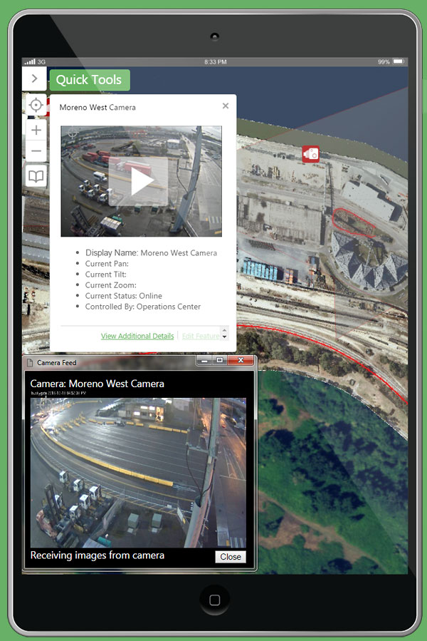
Which vessel is my camera looking at, and is there HazMat in that warehouse?
Where is the security light that was reported damaged, and do we have the right replacement parts?
Where are our assets that are actually worth repairing rather than replacing or disposing?
Which dock can accommodate the weight and size of this unusual cargo?
Which leases expiring in the next six months have rail access?
Enterprise Approach
Overcome silos of information and gain new efficiencies. Attain a common operating picture of your facility. Access through best practice enterprise security measures.
Knowledge Security
Capture the precious knowledge of your retiring workforce. Put modern knowledge management tools in the hands of a new generation. Provide critical information in a secure environment. Build resiliency, prepare for emergencies.
Decision Support
Leverage the data already in your facility and allow your staff to drive defensible, transparent decision making. Oversee operations via a map-driven dashboard. Automate and disseminate repetitive data tasks, making it easy for anyone to access the information they need.
Robust Geospatial Tools
Enesgy software solutions include a suite of tools designed to help manage port and marine terminal assets, security, documents, real estate, environmental, engineering, and maintenance, all through organization and presentation of data spatially and integration with existing systems to accelerate ROI.
Modern Architecture
Built on a best-in-class software and database foundation, Enesgy software is designed using a standards-based and easily supportable architecture. Configuration instead of customization reduces cost and promotes organization independence.
Deployment Options
Deployable behind your firewall or in your own private cloud where you capitalize and own the software, or hosted in the cloud through a subscription. Either way you own and have permanent access to your data.
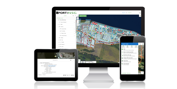
Maps and Apps Anywhere, Anytime, and on Any Device
Enesgy software uses an HTML5 JavaScript-based responsive software design so you can easily use your tools on a computer, tablet, or mobile device. Access Enesgy software from the office or the field to perform real-time data updates and analyses, present plans to stakeholders and commissioners, or respond to an emergency even if you are out of the office.
Integration
One of the main strengths of Enesgy software is its proven ability to integrate with a variety of other information systems. Integration with Enesgy can spatially enhance those systems or help correlate information within those systems using common locations. Enesgy software has been integrated with systems for:
- vessel and vehicle tracking
- lease management
- permit management
- command and control
- mass notification
- closed circuit TV
- access control
- weather
- traffic monitoring
- document management
- facilities management.
Contact us to learn how Enesgy software can integrate with and enhance your port or marine terminal systems.


NSGIS are the Geospatial People in Ports
NSGIS is an expert in geospatial system integration at ports, with decades of GIS and consulting experience. Enesgy software solutions are off-the-shelf products that fit ports and marine terminals of all sizes, large or small.
Enesgy software has been successfully deployed at multiple ports across the United States.